Projects
Flow over Complex Topography
In the coastal ocean, bottom topography varies continuously across a wide range of length scales. This is particularly evident in coral reef systems, where topography varies from branch (cm) to patch (m) to reef (km) scales. When waves and currents interact with this topography, they cause spatial patterns in pressure, flow, and turbulence. Ocean circulation models typically have grid cells > 50 m, so some of these processes are resolved and others are not. At present, the physics of these interactions are not included explicitly in most observational efforts, theoretical analyses, or modeling studies.
We are investigating how flows that vary at different time scales interact with topography composed of a range of length scales. Our goal is to develop mathematical models that accurately represent interactions between flow and reef topography and can be incorporated into circulation models. To do this, we are using a combination of field measurements from a coral reef site in Moorea, French Polynesia, and computer models of flow over real and idealized reef geometries.
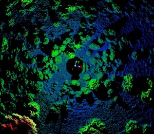
Example measurements of reef topography at the Moorea field site, made with a high resolution scanning sonar
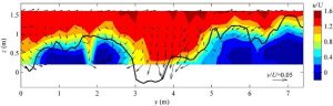
Spatial map of currents across a section of reef in Moorea, French Polynesia, measured using a tower of ADVs on a sliding traverse
Circulation, Mixing, and Oxygen Dynamics in Wind-Dominated Estuaries
Unlike most estuaries in which mixing is dominated by tides, many of North Carolina’s largest and most important estuaries have almost no tides and are instead dominated by the effects of wind. This means they behave in a profoundly different way than the traditional view of estuarine circulation. In contrast to the periodic, predictable mixing generated by tides, wind events are irregular and wind-driven currents and mixing are episodic. Using field measurements from the Neuse River estuary, we are investigating how circulation and mixing in the estuary respond to the wind.
Because wind-forced estuaries experience relatively little mixing, they can be very strongly stratified for much of the time. As a result, vertical mixing is limited and bottom water can become depleted in oxygen during warmer months when biological activity is high. We are investigating how the oxygen distribution in the Neuse is affected by wind events, with the goal of being able to better predict the frequency and duration of hypoxic and anoxic conditions in the estuary.
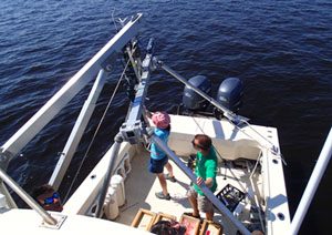
Photograph of instrument array to measure turbulent fluctuations in velocity and salinity
Wave Attenuation by Marshes
There is increasing recognition that natural habitats such as marshes can protect shorelines and property from erosion. Nature-based solutions to shoreline protection have been shown to have many benefits over traditional hardened structures like bulk heads, including habitat provision, nutrient removal, and the ability to evolve and persist as sea levels rise. One of the most important considerations when assessing a natural solution for shoreline protection is its capacity to attenuate wave energy and prevent erosion. As part of a NOAA funded project, we assessed the capacity of marshes within the North Carolina NOAA Sentinel Site to attenuate wave energy and protect shorelines. We used detailed measurements of bed elevations and vegetation properties, together with water level and wave measurements, to develop and ground truth a process-based model for wave transformation across marshes. The model is being used to assess the capacity of the marshes to attenuate waves under present conditions and possible future sea level scenarios. In an NC Sea Grant-funded project, we are extending the model to living shorelines that include sill features and marsh vegetation, testing the model using new field measurements, and developing the model into a web-based tool for living shoreline evaluation and design.
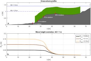
Top: Cross-shore elevation profile with modeled vegetation in green. Bottom: Model wave height predictions for an offshore water depth of 1 m.